Ocean floor geophysics delves into the hidden realms beneath the ocean’s surface, unraveling the geological processes and structures shaping the seafloor. By employing advanced geophysical techniques, scientists can map the ocean floor, investigate tectonic activity, and uncover the secrets of Earth’s crust beneath the waves. In this article, we embark on a journey to explore the significance of ocean floor geophysics, the innovative technologies driving scientific discovery, and the implications for understanding Earth’s dynamic geology.
Understanding Ocean Floor Geophysics
Ocean floor geophysics involves studying geological phenomena and processes beneath the ocean’s surface, including seafloor spreading, subduction zones, and mid-ocean ridges. Geophysicists utilize various remote sensing and imaging techniques to investigate the ocean floor’s structure, composition, and dynamics, providing insights into Earth’s tectonic evolution and the formation of ocean basins.
Seafloor Mapping
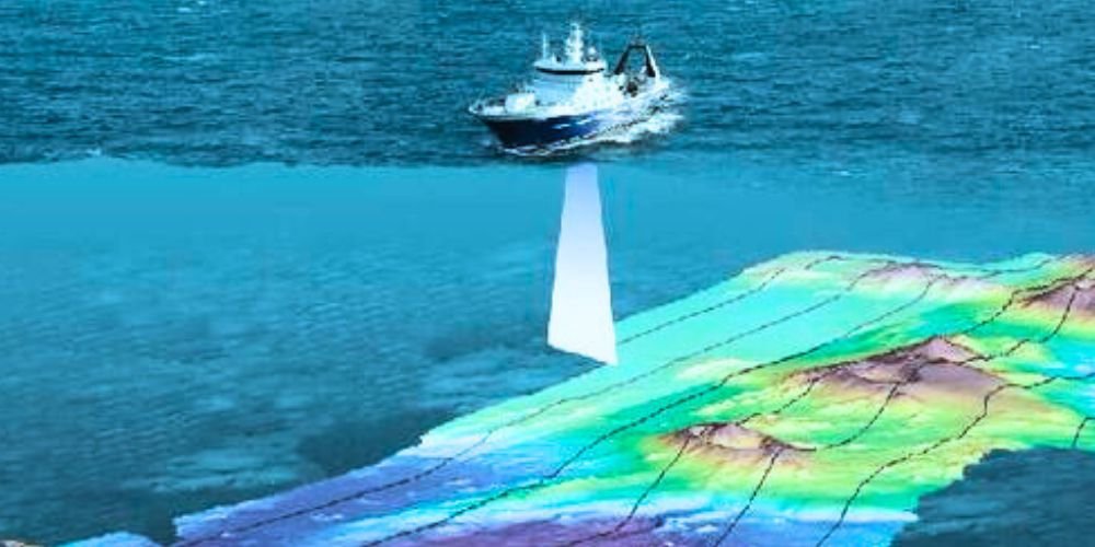
Seafloor mapping is a fundamental component of ocean-floor geophysics, enabling scientists to create detailed maps of seafloor topography and bathymetry. Bathymetric surveys using multibeam echosounders and sidescan sonars measure water depth and detect geological features, such as abyssal plains, seamounts, and underwater volcanoes. Seafloor mapping provides valuable data for understanding tectonic processes, sedimentation patterns, and geomorphological features of the ocean floor.
Seismic Imaging
Seismic imaging techniques, such as seismic reflection and refraction surveys, are used to study the subsurface structure and composition of the ocean crust and upper mantle. Seismic waves generated by air guns, seismic sources, or explosives penetrate the seafloor. Geological interfaces reflect or refract them, allowing scientists to image subsurface structures, such as crustal boundaries, fault zones, and magma chambers. Seismic imaging provides crucial information for studying tectonic plate boundaries, earthquake dynamics, and volcanic activity in the ocean environment.
Magnetometry and Gravity Surveys
Magnetometry and gravity surveys investigate the magnetic and gravitational anomalies associated with seafloor spreading and crustal deformation. Magnetometers measure variations in Earth’s magnetic field caused by magnetic minerals in the ocean crust, providing insights into the magnetic polarity reversals recorded in marine magnetic anomalies. Gravity surveys measure variations in Earth’s gravitational field caused by crustal and mantle density variations, revealing crustal thickness, crustal density, and lithospheric structure beneath ocean basins.
Advancements in Ocean Floor Geophysics
Recent advancements in technology and instrumentation are revolutionizing ocean floor geophysics, expanding our ability to explore and understand Earth’s dynamic geology beneath the oceans.
Autonomous Underwater Vehicles (AUVs)
Autonomous underwater vehicles (AUVs) are uncrewed vehicles equipped with sensors and instruments for conducting high-resolution mapping and imaging of the ocean floor. AUVs can navigate autonomously and collect data in remote and inaccessible ocean regions, providing detailed bathymetric maps, seismic profiles, and magnetic surveys with high precision and resolution. AUVs are invaluable for exploring deep-sea environments, investigating hydrothermal vent systems, and studying submarine volcanic eruptions.
Marine Seismic Technology
Advancements in marine seismic technology, such as ocean bottom seismometers (OBS) and marine seismic streamers, enhance our ability to image and monitor tectonic processes and seismic activity beneath the ocean floor. OBS arrays deployed on the seafloor record seismic waves generated by earthquakes, volcanic eruptions, and tectonic events, providing insights into the structure and dynamics of the Earth’s crust and mantle. Marine seismic streamers towed behind research vessels generate high-resolution seismic images of the subsurface, revealing crustal structures, fault systems, and magma chambers beneath the ocean basins.
Satellite Remote Sensing
Satellite remote sensing technologies, such as altimetry and gravimetry, are used to monitor and measure ocean surface topography and changes in the gravity field. Satellite altimetry measures variations in sea surface height caused by ocean currents, tides, and seafloor topography, providing information on seafloor bathymetry and ocean circulation patterns. Satellite gravimetry measures variations in Earth’s gravitational field caused by changes in ocean mass and density, enabling scientists to study ocean currents, sea level rise, and ocean-atmosphere interactions.
Applications of Ocean Floor Geophysics
Ocean floor geophysics has diverse applications in scientific research, resource exploration, and environmental monitoring. It contributes to our understanding of Earth’s dynamic geology and the evolution of ocean basins.
Tectonic Studies and Plate Tectonics
Ocean-floor geophysics is crucial for studying tectonic plate boundaries, plate motions, and crustal deformation processes in the ocean environment. Scientists use geophysical data to investigate mid-ocean ridges, transform faults, and subduction zones, revealing the mechanisms that drive tectonic plate motion and earthquakes along plate boundaries. Ocean floor geophysics provides evidence for the theory of plate tectonics and helps unravel the geological history and evolution of ocean basins over millions of years.
Hydrocarbon Exploration
Ocean floor geophysics is used in hydrocarbon exploration to identify and evaluate potential oil and gas reservoirs beneath the seafloor. Seismic imaging techniques, such as seismic reflection surveys and marine seismic streamers, map geological structures, including anticlines, faults, and salt domes, that may contain hydrocarbon accumulations. Gravity and magnetometry surveys help delineate sedimentary basins, source rocks, and hydrocarbon traps, guiding exploration efforts and reducing drilling risks in offshore oil and gas fields.
Environmental Monitoring and Hazards Assessment
Ocean floor geophysics supports environmental monitoring and hazard assessment in coastal and marine environments, including tsunami warning systems, submarine landslides, and volcanic eruptions. Seismic monitoring networks and seafloor observatories provide real-time data on seismic activity, crustal deformation, and volcanic unrest, helping scientists monitor and forecast geological hazards like earthquakes, tsunamis, and submarine volcanic eruptions. Geophysical surveys also assess geological hazards in offshore and coastal regions, such as submarine landslides, fault movements, and seafloor subsidence.
Challenges and Future Directions
Ocean floor geophysics faces various challenges, including technological limitations, complex data interpretation, and the need for international collaboration to explore and understand Earth’s dynamic geology beneath the oceans.
Technological Advancements
Advancing ocean floor geophysics requires continued investment in developing and deploying innovative technologies and instrumentation to map and image the ocean floor. Improving the resolution, accuracy, and coverage of geophysical surveys and integrating multiple datasets from different platforms and sensors will enhance our ability to explore and understand Earth’s complex geology beneath the oceans.
Data Integration and Interpretation
Integrating and interpreting multidisciplinary geophysical data from diverse sources, such as seismic surveys, satellite observations, and marine geophysical databases, poses challenges for ocean floor geophysics research. Developing advanced data processing algorithms, computational models, and visualization tools will facilitate the analysis and interpretation of complex geophysical datasets, enabling scientists to extract meaningful insights into Earth’s dynamic processes and structures beneath the ocean basins.
International Collaboration
International collaboration and cooperation are essential for addressing global challenges in ocean floor geophysics research, including data sharing, methodological standardization, and capacity building in developing countries. Collaborative initiatives, such as the International Ocean Discovery Program (IODP) and the Ridge Interdisciplinary Global Experiments (RIDGE), bring together scientists from around the world to study tectonic processes, seafloor spreading, and subduction zones, fostering interdisciplinary research and advancing our understanding of Earth’s dynamic geology beneath the oceans.
Conclusion
Ocean floor geophysics is a dynamic, interdisciplinary field crucial to exploring and understanding Earth’s complex geology beneath the oceans. By employing advanced geophysical techniques, scientists can map the ocean floor, investigate tectonic processes, and unravel the mysteries of Earth’s dynamic evolution over millions of years. As we continue to explore and study the ocean environment, the journey of ocean-floor geophysics is guided by curiosity, discovery, and collaboration, ensuring a deeper understanding of Earth’s dynamic geology beneath the waves.


