Marine geophysics is the scientific gateway to unraveling the mysteries of Earth’s submerged landscapes and the geologic processes that occur beneath the ocean. This article explores the multifaceted world of marine geophysics, shedding light on its significance, the advanced technologies employed, its role in understanding seafloor features, and the transformative potential for expanding our knowledge of Earth’s dynamic crust beneath the waves.
The Significance of Marine Geophysics
Marine geophysics is a discipline that plays a pivotal role in deciphering the structure and composition of Earth’s crust beneath the ocean. It provides crucial insights into tectonic plate movements, seafloor spreading, and the geological history of the ocean basins. Understanding the significance of marine geophysics is fundamental to unraveling the dynamic processes that shape the Earth’s lithosphere.
Tectonic Plate Interactions and Seafloor Spreading
One of the primary contributions of marine geophysics is its role in studying tectonic plate interactions and the process of seafloor spreading. By analyzing the magnetic properties and topography of the ocean floor, researchers can trace the movement of tectonic plates, revealing the intricate processes that lead to the creation of new seafloor at mid-ocean ridges.
Subsurface Imaging and Seismic Studies
Marine geophysics utilizes advanced subsurface imaging techniques, with seismic studies serving as a cornerstone of this exploration. By sending acoustic waves through the ocean floor and measuring their reflections, scientists can create detailed images of subsurface structures, providing invaluable information about the composition and architecture of the Earth’s crust.
Geological History and Climate Change Records
The layers of sediment on the ocean floor serve as a geological archive, recording the Earth’s history and climatic changes over millions of years. Marine geophysics enables scientists to analyze sediment cores, extract information about past environmental conditions, and unravel the complex interplay between geologic processes and climate change.
Technologies in Marine Geophysics
The field of marine geophysics relies on cutting-edge technologies to probe the ocean’s depths and unveil the secrets hidden beneath the seafloor. Understanding these advanced technologies is essential for conducting precise and detailed geophysical studies.
Multibeam Sonar Mapping
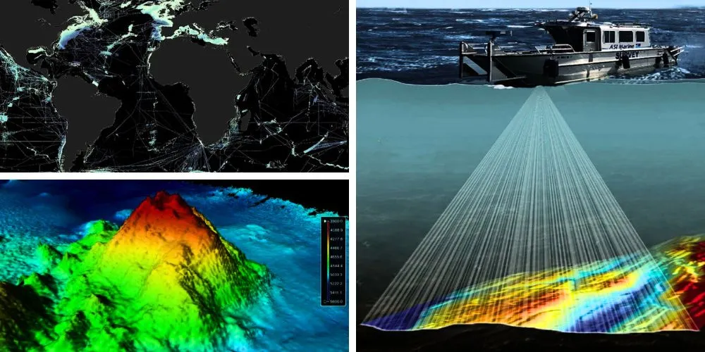
Multibeam sonar mapping is a technology that allows scientists to create high-resolution, three-dimensional maps of the seafloor. By emitting multiple sonar beams simultaneously and measuring their reflections, researchers can produce detailed bathymetric maps, revealing the ocean floor’s topography with unprecedented accuracy.
Seismic Reflection Profiling
Seismic reflection profiling generates acoustic waves at the ocean surface and analyzes the echoes reflected from subsurface layers. This technique provides detailed information about the composition and structure of the Earth’s crust, helping scientists understand the architecture of sedimentary layers and identify potential energy resources.
Magnetometer Surveys
Magnetometer surveys are crucial for studying the magnetic properties of the ocean floor. As molten lava solidifies and forms new seafloor at mid-ocean ridges, it records the Earth’s magnetic field at the time of its formation. Magnetometer surveys help create magnetic anomaly maps, identifying magnetic striping patterns and tectonic plate movements.
Gravity Measurements
Gravity measurements are employed in marine geophysics to study variations in the Earth’s gravitational field. Anomalies in gravity can indicate subsurface features such as seamounts, underwater volcanoes, or variations in crustal density. Gravity data contribute to our understanding of seafloor morphology and crustal structures.
Seafloor Features Explored by Marine Geophysics
Marine geophysics provides a window into a diverse range of seafloor features, each holding clues about the Earth’s geological history and ongoing processes beneath the ocean.
Mid-Ocean Ridges: Birthplaces of New Seafloor
Mid-ocean ridges are mountain ranges where tectonic plates diverge, allowing magma to rise from the mantle and create new seafloor. Marine geophysics, especially through magnetometer surveys and seismic studies, has been instrumental in mapping these ridges and understanding seafloor spreading processes.
Submarine Volcanoes and Seamounts
Submarine volcanoes and seamounts, often hidden beneath the ocean surface, are brought to light through marine geophysics. Seismic reflection profiling and multibeam sonar mapping reveal the topography and geological characteristics of these features, offering insights into volcanic activity and the dynamics of the ocean floor.
Abyssal Plains: Flat and Sediment-Covered Regions
Abyssal plains, expansive flat areas on the ocean floor, are extensively studied using marine geophysics to understand sedimentation processes and map subsurface structures. Seismic studies help reveal the composition of sediments, while gravity measurements aid in identifying subsurface features beneath the plains.
Trenches: Deep Subduction Zones
Submarine trenches, formed at subduction zones where tectonic plates converge, are explored through marine geophysics to understand the complex processes of plate subduction. Seismic studies provide insights into the structure of the Earth’s crust in these high-pressure environments, and gravity measurements help characterize the density variations.
Transformative Potential of Marine Geophysics
The trajectory of marine geophysics points towards a future filled with transformative discoveries, enhanced understanding of Earth’s processes, and applications that benefit diverse scientific disciplines.
Climate Modeling and Prediction
Marine geophysics contributes to climate modeling by providing essential data on ocean circulation patterns, seafloor topography, and the history of climate change recorded in sediment layers. This information enhances our ability to predict future climate scenarios and understand the impacts of environmental changes.
Energy Resource Exploration
The knowledge gained through marine geophysics is invaluable for the exploration of energy resources. Seismic studies help identify potential oil and gas reserves beneath the ocean floor, contributing to the sustainable development of energy resources and minimizing the environmental impact of exploration activities.
Natural Hazard Assessment
Marine geophysics plays a crucial role in assessing and mitigating natural hazards, including underwater earthquakes, tsunamis, and volcanic eruptions. By understanding the geophysical processes at play, scientists can develop early warning systems and strategies for minimizing the impact of these events on coastal communities.
Deep Biosphere Exploration
Marine geophysics plays a crucial role in exploring the deep biosphere, a largely uncharted realm located beneath the ocean floor. Subsurface imaging techniques help identify potential habitats for microbial life, and the study of hydrothermal vent systems offers insights into the extreme conditions that support unique ecosystems.
Conclusion
Marine geophysics stands at the forefront of unraveling Earth’s geological secrets beneath the ocean’s surface. As technology advances and our understanding deepens, this field continues to contribute essential knowledge to diverse scientific disciplines, from climate science to energy exploration. With each seismic survey, gravity measurement, and sonar mapping expedition, marine geophysics propels us further into the profound complexities of our planet’s dynamic crust, fostering a deeper appreciation for the interconnected processes shaping our world beneath the waves.


