Oceanographic mapping, the process of creating detailed maps of the seafloor and ocean environment, is essential for understanding the complex and dynamic nature of the world’s oceans. These maps provide valuable insights into marine geology, habitat distribution, and oceanographic processes, supporting scientific research, resource management, and maritime activities. In this article, we embark on a journey to explore the importance of oceanographic mapping, the technologies driving advancements in marine cartography, and the applications of detailed seafloor maps.
Understanding Oceanographic Mapping
Oceanographic mapping involves systematically collecting data to create accurate and comprehensive maps of the seafloor, water column, and marine features. These maps depict bathymetry, the underwater topography of the ocean floor, as well as geological structures, underwater hazards, and biological habitats. Oceanographic mapping encompasses a variety of techniques, including acoustic surveys, satellite remote sensing, and hydrographic mapping, each offering unique advantages for exploring and understanding the ocean environment.
Acoustic Surveys
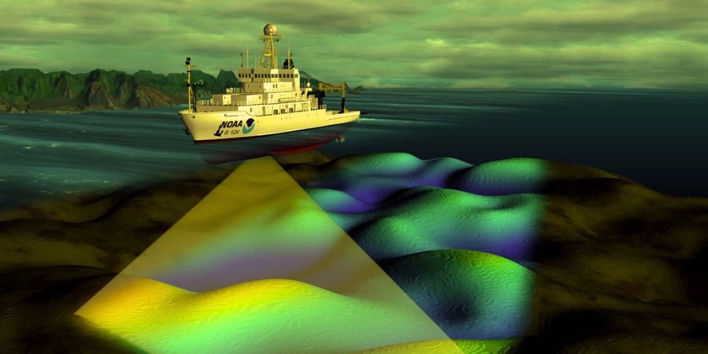
Acoustic surveys are the primary method for mapping the seafloor and underwater features in the ocean. These surveys use sound waves from sonar systems mounted on ships or underwater vehicles to measure water depth and detect objects and geological formations on the seabed. Multibeam echosounders and sidescan sonars are commonly used acoustic instruments for high-resolution seafloor mapping, providing detailed bathymetric data and imagery of underwater features.
Satellite Remote Sensing
Satellite remote sensing enables the mapping of ocean surface properties, such as sea surface temperature, ocean color, and sea level, over large spatial scales. Satellites equipped with radar and optical sensors can monitor oceanographic phenomena, such as ocean currents, eddies, and upwelling zones, and provide valuable data for understanding global ocean dynamics and climate variability. Satellite altimetry measures sea surface height, maps ocean topography, and identifies underwater features such as seamounts and ridges.
Hydrographic Mapping
Hydrographic mapping involves collecting detailed bathymetric data and nautical charts to support safe and efficient maritime navigation. Hydrographic surveys, conducted by specialized vessels equipped with single-beam echo sounders and depth sounders, provide accurate depth measurements and identify navigational hazards, such as shoals, rocks, and shipwrecks. Hydrographic charts, produced by national hydrographic offices and international organizations, are essential for ensuring the safety of ships and mariners at sea.
Applications of Oceanographic Mapping
Oceanographic mapping supports a wide range of scientific research, environmental management, and maritime activities, contributing to our understanding of the ocean environment and its role in shaping the Earth’s climate and ecosystems.
Marine Geology and Habitat Mapping
Oceanographic mapping provides valuable insights into marine geology, including seafloor morphology, geological structures, and sedimentary processes. Detailed bathymetric maps and geological surveys enable scientists to study submarine features, such as trenches, ridges, and volcanic seamounts, and understand tectonic processes, seafloor spreading, and plate boundary interactions. Habitat mapping identifies critical marine habitats, such as coral reefs, kelp forests, and deep-sea ecosystems, and informs conservation and management efforts aimed at protecting vulnerable marine species and ecosystems.
Resource Exploration and Management
Oceanographic mapping supports the exploration and management of marine resources, including fisheries, mineral deposits, and energy sources. Seafloor mapping identifies potential fishing grounds, spawning areas, and nursery habitats for commercial fish species, helping fisheries managers implement sustainable fishing practices and protect essential fish habitats. Bathymetric surveys also identify mineral-rich areas, such as hydrothermal vents and manganese nodules, for potential mineral exploration and deep-sea mining activities.
Maritime Navigation and Safety
Oceanographic mapping is crucial in maritime navigation and safety, as it provides accurate and up-to-date charts for ships and mariners. Nautical charts, produced from hydrographic surveys and satellite data, enable safe passage through shipping lanes, ports, and coastal waters, reducing the risk of collisions, groundings, and maritime accidents. Real-time monitoring of oceanographic conditions, such as currents, tides, and sea ice, further enhances maritime safety and efficiency for commercial shipping, recreational boating, and offshore operations.
Advancements in Oceanographic Mapping Technologies
Recent advancements in oceanographic mapping technologies drive innovation and expand the capabilities for exploring and mapping the ocean environment.
Autonomous Mapping Systems
Advancements in autonomous mapping systems, such as autonomous underwater vehicles (AUVs) and uncrewed surface vessels (USVs), are revolutionizing oceanographic mapping by enabling high-resolution surveys over large areas with minimal human intervention. These autonomous platforms can collect bathymetric data, imagery, and water column measurements in real time, providing detailed maps of the seafloor and underwater features with unprecedented efficiency and accuracy.
High-Resolution Imaging Technologies
High-resolution imaging technologies, such as multibeam echosounders and synthetic aperture sonars, enhance the resolution and clarity of seafloor maps and imagery. These advanced sensors can produce detailed three-dimensional maps of the seafloor, revealing fine-scale features, such as underwater canyons, channels, and shipwrecks, with high accuracy and precision. High-resolution mapping technologies are invaluable for studying marine habitats, geological processes, and archaeological sites in greater detail than ever.
Integrated Data Platforms
Integrated data platforms, such as geographic information systems (GIS) and oceanographic data portals, are streamlining the storage, analysis, and visualization of oceanographic mapping data. These platforms integrate bathymetric data, satellite imagery, environmental parameters, and other oceanographic datasets into interactive maps and models, allowing researchers, policymakers, and stakeholders to access and analyze oceanographic data for scientific research, resource management, and informed decision-making.
Challenges and Future Directions
Despite their importance, oceanographic mapping efforts face various challenges, including funding constraints, technical limitations, and the need for international collaboration.
Funding and Resources
Securing adequate funding and resources for oceanographic mapping projects is essential for conducting comprehensive surveys, maintaining infrastructure, and developing innovative mapping technologies. Many mapping efforts suffer from limited financial support, staffing shortages, and competing priorities, hindering their ability to achieve conservation goals and address emerging threats in the marine environment.
Technical Limitations
Technical limitations, including equipment costs, data processing capabilities, and access to remote and extreme environments, pose challenges for oceanographic mapping efforts. Advances in mapping technologies, data processing algorithms, and remote sensing platforms are needed to overcome these technical hurdles and improve the efficiency, accuracy, and coverage of oceanographic mapping surveys in challenging oceanographic conditions.
International Collaboration
International collaboration and cooperation are essential for addressing global challenges in oceanographic mapping, including data sharing, standardization of mapping methodologies, and capacity building in developing countries. Collaborative initiatives, such as the Seabed 2030 project and the Global Multi-Resolution Topography (GMRT) synthesis, aim to map the seafloor by 2030 and provide open access to bathymetric data for scientific research and environmental management worldwide.
Conclusion
Oceanographic mapping is critical in advancing our understanding of the ocean environment, supporting scientific research, environmental management, and maritime activities. By mapping the seafloor and underwater features, we can unravel the mysteries of the deep sea, discover new habitats and species, and protect marine ecosystems for future generations. As we continue to explore and map the ocean environment, the journey of oceanographic mapping is guided by the principles of collaboration, innovation, and stewardship, ensuring a healthier and more sustainable future for our oceans and planet.


