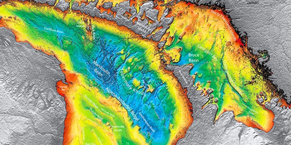
Bathymetry, the study and mapping of the underwater topography of the ocean floor, serves as a crucial discipline in oceanography, unraveling the mysteries hidden beneath the waves. This article explores the expansive realm of bathymetry, examining its significance, tracing the evolution of critical technologies, and investigating diverse applications, while also envisioning the transformative possibilities it holds for understanding Earth’s submerged landscapes.
The Significance of Bathymetry
Bathymetry holds significant importance as it provides insights into the complex and dynamic features of the ocean floor. By mapping underwater topography, scientists can gain a deeper understanding of the geological processes shaping the seabed, explore marine ecosystems, and contribute to various fields, including climate science, resource management, and marine navigation.
Understanding Seafloor Geology and Tectonics
Bathymetry plays a crucial role in deciphering the seafloor’s geology and tectonics. By mapping features such as mid-ocean ridges, subduction zones, and abyssal plains, scientists can gain a deeper understanding of Earth’s tectonic processes, plate boundaries, and the formation of underwater mountain ranges.
Geological Hazard Assessment
Accurate bathymetric data is essential for assessing geological hazards, including underwater earthquakes, tsunamis, and submarine volcanic activity. Identifying seafloor faults and mapping potential hazard zones helps develop early warning systems and risk mitigation strategies for coastal communities.
Marine Habitat Mapping and Biodiversity Studies
Bathymetry aids in mapping marine habitats and underwater landscapes critical for biodiversity studies. Understanding the ocean floor’s topography allows scientists to identify habitats such as coral reefs, seamounts, and hydrothermal vents, providing valuable insights into the distribution and health of marine ecosystems.
Navigation and Safe Maritime Operations
Accurate bathymetric charts are fundamental for safe maritime navigation. Detailed information about seafloor depths, underwater features, and potential hazards ensures the safety of shipping routes, submarine cable installations, and offshore infrastructure development.
Evolution of Key Technologies in Bathymetry
The journey of bathymetry is intricately woven with the evolution of key technologies that have continually advanced our ability to map underwater topography precisely.
Single-Beam and Multibeam Echosounders
Single-beam and multibeam echosounders are instrumental technologies in bathymetry. Single-beam echosounders emit a single sonar beam to measure seafloor depths, while multibeam systems use multiple beams to capture a wider swath of the ocean floor. Multibeam technology has significantly improved mapping efficiency and data accuracy.
Satellite Altimetry
Satellite altimetry measures the height of the ocean surface from space, providing indirect information about seafloor topography. Scientists can infer the underlying bathymetry by analyzing variations in sea surface height. Satellite altimetry is particularly valuable for mapping large-scale features, such as mid-ocean ridges.
Autonomous Underwater Vehicles (AUVs)
AUVs equipped with advanced sonar systems contribute to high-resolution bathymetric mapping. These autonomous vehicles can navigate the underwater environment, collect data in challenging terrains, and provide detailed bathymetric surveys of specific areas of interest.
Satellite-Based Bathymetry
Recent advancements in satellite-based bathymetry utilize optical satellite imagery to estimate seafloor depths. By analyzing the interaction of light with the water column, researchers can infer information about the bathymetry. This approach offers a cost-effective and global-scale solution for bathymetric mapping.
Diverse Applications of Bathymetry
Bathymetry has diverse applications that extend beyond oceanography, impacting various industries and scientific disciplines.
Offshore Resource Exploration
Bathymetric maps are crucial in offshore resource exploration, including oil and gas exploration, mineral extraction, and renewable energy projects. Accurate seafloor mapping helps identify suitable locations for resource extraction and informs sustainable resource management practices.
Climate Change Research
Bathymetry contributes to climate change research by providing data on the volume and depth of the ocean basins. Changes in seafloor topography, such as the melting of polar ice caps or shifts in sediment patterns, can impact ocean circulation and climate dynamics. Bathymetric data is essential for understanding these changes and their implications for the global climate system.
Submarine Cable Planning and Installation
The planning and installation of submarine communication cables rely on precise bathymetric data. Understanding the seafloor topography helps identify suitable routes for laying cables, avoiding underwater obstacles, and ensuring the integrity of the communication infrastructure that connects continents.
Conservation and Marine Protected Areas
Bathymetric mapping contributes to conservation efforts by identifying and assessing marine habitats that warrant protection. By mapping critical habitats and biodiversity hotspots, scientists and policymakers can designate marine protected areas to safeguard vulnerable ecosystems and promote sustainable fisheries.
Transformative Possibilities and Future Outlook
The trajectory of bathymetry points towards a future filled with continued innovation, integration, and unprecedented possibilities.
High-Resolution Global Bathymetric Maps
Advancements in technology, including satellite-based bathymetry and autonomous underwater vehicles, hold the potential to create high-resolution global bathymetric maps. These maps could provide a comprehensive and detailed view of the ocean floor, enhancing our understanding of Earth’s submerged landscapes.
Climate-Driven Changes and Adaptation
It will play a vital role in monitoring climate-driven ocean changes, such as rising sea levels and alterations in ocean circulation patterns. Scientists can track these changes by continuously updating bathymetric data and developing adaptive strategies to mitigate their impacts on coastal communities.
Exploration of Uncharted Regions
Bathymetry will continue to contribute to the exploration of previously uncharted ocean regions. As technology advances, researchers can target areas that remain poorly understood, uncovering new geological features, marine habitats, and potential sources of biodiversity.
Integration with Emerging Technologies
Integrating bathymetry with emerging technologies, such as artificial intelligence and machine learning, holds exciting possibilities. These technologies can enhance data processing, automate feature recognition, and optimize the extraction of valuable information from bathymetric datasets.
Conclusion
Bathymetry is a key discipline in unlocking the secrets of Earth’s oceans, revealing the submerged landscapes that shape our planet. As we navigate the depths with advanced technologies, the significance of bathymetry is both profound and essential. Through continued research, technological advancements, and interdisciplinary collaborations, bathymetry will remain at the forefront of oceanography, significantly contributing to our understanding of the dynamic and complex underwater world.


